Have You Biked Buller? If not, then why not?
Bike Buller…Where The Trails Keep On Giving. We’ve heard and read a lot about the trails at Mount Buller, so we decided to head on down there for ourselves.
It seems to be one of the Meccas for mountain biking in Australia, especially on the Eastern side of the country. We decided to make a B-Line straight there although some people will turn it into a bit of a mountain bike road trip by visiting Stromlo, Thredbo, Falls Creek and other destinations. We only had a few days, so wanted to keep them all for the trails at Buller.
A Long Way Down
It’s a bloody long drive so we broke it up into two parts by stopping off at Gundagai on the way down and the way back. From Sydney, it takes around eight hours (770kms, approx) to get to Mount Buller. You can do it in one day or split it up into two days, which is what we did.

It’s a fairly long trip. So if you do head down, we would recommend you turn it into either a MTB road trip or spend at least 4-5 days down there. Pic: ©Google Maps
Gundagai is a good stop off point because it has a motel and an RSL and they do a pretty good steak and chips which can be washed down with some fairly good beers on tap. Which is exactly what we did. Bish, bash bosh…get it down ya! Although there were some odd items on the menu.

The steak is so good, they named it twice. Scotch Scotch? anyone?

A very expensive chip! and it’s small!! What’s it made of?
We also stopped off at Pushys (Canberra) to pick up some spare brake pads. We’d heard about the descents on some of the trails at Buller, so we made a last minute decision to grab some back ups.

Pushys BSpoke Cafe. Very noice indeed. Prepare yourself for all sorts of drool.
Anyway, this gave us the perfect opportunity to drool over our hipster pulled pork rolls whilst drooling over some very nice bikes at Pushys trendy Café/Bike store, aptly named Pushys Plus.
Changing Landscapes
The landscape changes as you drive down, from vast open rolling golden fields and farm lands to the ever rising Australian Alpine region looming in the distance, which of course was formed by the Great Dividing Range.

The vast rolling, golden fields make way for more verdant surroundings as you get closer to Mt.Buller. Pic:©Tyres and Soles
When you get closer to the base of Mount Buller, you find yourself driving through deep forests of peculiarly named trees such as the Woollybutt and higher up, the Alpine Ash (not such a funny name).
The Delatite River can be seen flowing past on the left but then soon begins to shrink in size as you head up the steep and twisting Mt.Buller Road. If you have a fear of heights you may want to close your eyes on some sections of this road, but only if you’re the passenger of course!

The stark gums set against the verdant greens and dark soils, make for a spectacularly contrasting setting. Pic:©Tyres and Soles
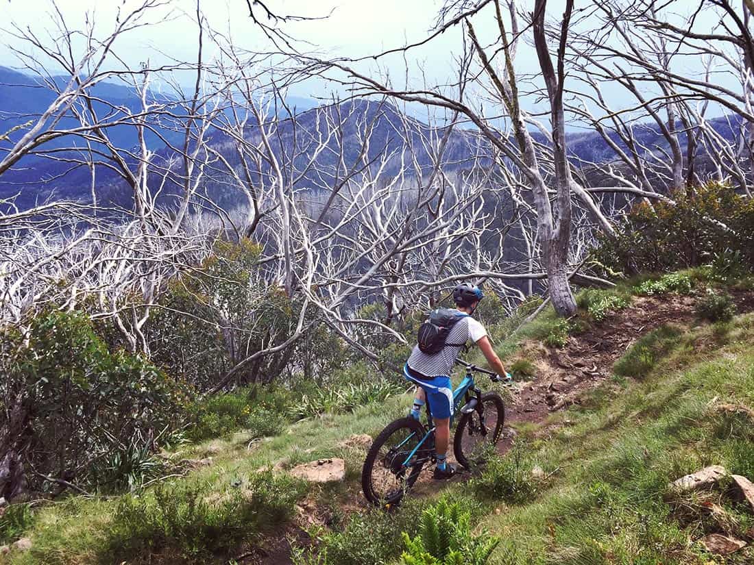
The upper slopes consist mostly of the ghostly white Snow Gums (Eucalyptus pauciflora) standing out like some strange boney creatures against the vivid blue sky, although we didn’t see much of that until our last day, typical eh.
Accommodation
We stayed at the Akla Ski lodge which was great. Plenty of room, with a large kitchen lounge area and tonnes of storage for the bikes. Plus a very handy dry room.
Lodges can be a little daunting as you’re never quite sure who you’re going to be sharing with, unless you book with a group of friends. So there was some trepidation about the people we were going to be living with over the following days.

The Akla Ski lodge. It had everything you’d ever need for a mountain bike or hiking adventure.

The Akla Ski lodge. A good sized kitchen and communal area to meet and chat with your riding buddies.
Fortunately as it turned out everyone was very nice and well behaved. It’s always fun to share a few drinks in the evening and find out about the trails on the other side of the country. There were a couple of guys from Perth on a plane/road trip riding all the well known trails in Victoria, and then heading over to Tasmania to ride Derby et al.
Pea Soup
I’m not going to beat around the bush. The weather was crap! Rain, high winds, more rain and fog so thick it would have been a little foolhardy to ride in.
The chair lifts were closed due to the high winds, so our plan of riding the gravity trails for two days came to a crashing halt, we just hoped it would clear enough for one of the days for us to experience them.

Misty weather wasn’t ideal but it added a sense of doom to the trails. Is that a good thing? Pic:©Tyres and Soles
But, after coming this far we just had to get out there, so lucky for us we spotted a window of clear weather. Thus ensued the mad dash and scramble for gear, snacks and a quick bike check and we were out the door like greased lightning.

Misty Twist, doing what it says, being twisty and misty. Pic:©Tyres and Soles
The Trails
There are some easy trails that are worth checking out which can be used as a warm up for the longer rides or just a quick spin if the weather is bad. Soul Revival and One Tree Hill are easy level trails with no tricky obstacles, just easy going, flowy and thoroughly enjoyable.
Once warmed up, we decided to hit the longer trails that were near our lodge, starting with Gang Gangs, which turned into Woolybutt and then onto Corn Hill Summit. Gang Gangs and Woolybutt are a great taste of what’s to come. Flowy twisty turns, a good mix of ups and downs and some glimpses of the stunning valley, below.
We got to Corn Hill pretty quickly so we decided to keep on riding to Howqua Gap. This is where you can begin the Epic Trail proper, but not today. We decided to head back via Trigger Happy, which turns into Medusa and some testing pinch climbs.

The effects of Altitude…it’s real folks. Trying to smile for this shot was painful. I collapsed once I took the shot. Pic:©Tyres and Soles
We’re not top-level athletes, far from it, but we like to think we’re above average fitness. We ride/hike most weekends (Sat and Sun) and frequent the gym during the week, but as we made our way up Medusa and Split Rock, something was amiss.
We found ourselves getting out of breath and having to stop, a lot! Frustration turned into a sort of pained laughter as it dawned on us that it could be the effects of altitude.
Agreed, we’re not in the Himalayas but you actually don’t need to go that high to feel the effects. So be prepared for this folks. However, you will adjust pretty quickly.

There are many beautiful spots to take in the view (and a breather). Don’t rush, slow down and enjoy it all. Not sure what’s going on with my face in this picture…must be the effects of altitude! Pic:©Tyres and Soles
After a climb comes a descent. After our altitude sickness climb of Trigger Happy and Medusa, we were treated to Misty Twist, and it couldn’t of come any sooner.
It’s a fairly short section but oh so worth it. The trail, like a lot of the trails down here, have been built very well. It’s fast and flowy with no technical areas to be concerned about, just flat out fun.

Mt.Buller – Split Rock Trail. Just sublime! Pic:©Tyres and Soles
There’s some climbing at the end of Misty Twist, of course. You can’t go down without having to go back up, but it’s very enjoyable as you ride through the stark white snow gums set against dark green and browns of the surrounding flora.
Clancy’s Run was the next trail that connects from Misty Twist. It’s another short yet fast section with some rocky sections to keep you on your toes, but nothing too technical. We really enjoyed this one, as it was a little rougher than Misty Twist.

Rebecca making her way up the switchbacks on the last section of Split Rock. It’s a grind but well worth it. Pic:©Tyres and Soles
Clancy’s Run will spit you out on to the Corn Hill fire road junction. From here we took the Wombat Run trail which is a steady climb and connects to Split Rock, which is a little more challenging with a couple of tricky switchbacks to navigate and some rough loose rock sections. It’s all climbing, no descent on this one.
Split Rock will spit you back out onto the Family Trail with it’s now much welcomed tarmac path.
The combination of the previous trails, plus some altitude, meant it started to become a grind for us, so we decided to head back to the lodge to relax and crack open a few frosties.

When in Buller. Pic:©Tyres and Soles
The Delatite River Trail – 12kms
One of the must rides is the Delatite River Trail. It starts at the Corn Hill Road junction and right off the bat you’re put into a pretty steep steep fire road section, so just be ready for this. The trail then turns into a very fast and smooth earth road, taking you all the way down to the river level.

The Delatite River Trail. So many lovely spots to stop and take it all in. Pic©Tyres and Soles
As the road is smooth, it can get very fast indeed. You’ll be reaching speeds of over 60kms in a few seconds. You need to be mindful of this or you’ll end up catapulting off the water bars and into the the air, never to be seen again.

Stopping to appreciate where you are is a big part of why we ride. Pic©Tyres and Soles
As you get down to the river level, you’ll hit the first of many log bridges, which cross the Delatite River. These are stunning and a must stop off point for the obligatory photo. Be prepared to take longer than expected on your first run, with all the photo opportunities.

One of many log bridges that you cross on the Delatite River Trail. Just stunning! Pic:©Tyres and Soles
The Epic Trail – 40km
The word “Epic” shouldn’t be used lightly when naming a mountain bike trail. To be eligible for the official title of an Epic trail, there are certain requirements that need to be met.
What’s more interesting is that the trail is in fact the Southern Hemisphere’s first and only International Mountain Bicycling Association (IMBA) accredited Epic trail. Wow, that’s a mouthful.
The 40.39km trail offers a long distance, cross-country descending ride, providing stunning views across the Victorian High Country.

Stonefly Trail. Beware, the demanding photo regime may start to take it’s toll at this point, so remember to smile sincerely. Pic:©Tyres and Soles
The trail starts back in the village itself but where it starts to get really interesting is when you reach the wooden hut at Howqua Gap. You will presented with two choices at this junction. You can climb up the mighty Stonefly Trail or you can take the fire road down to Telephone Box Junction. The latter will re-connect you back with the Epic Trail.
We took the Stonefly Trail so we could experience the descent, which we’d heard so much about, but first, we had to get up there.
Stonefly Trail – Ascent 6kms
We wont beat around the bush, the Stonefly climb is tough! It has a good mix of technical switchbacks, challenging pinch sections and it even has some flowy parts, which our legs were very thankful for.
On the way up, we got caught in a big downpour. Luckily, we packed out waterproof jackets and it wasn’t actually cold. It could of been quite a different story if it was cold and sans waterproofs.

Our trusty steeds at Bluff Spur Memorial Hut. This is a great spot to rest the legs and prepare yourself for the Stonefly descent. Pic:©Tyres and Soles
We were not in any rush so we took plenty of breaks on the way up, but most of all to stop and take it all in. It’s an incredibly beautiful part of the mountain and if all you’re doing is focused on the trail ahead and grinding it out, then you’re missing a beat.
For the climb itself, you should expect anywhere from fifty minutes to infinity to get to the top.
Stonefly Trail – Descent 4kms
We’d heard a lot about the Stonefly descent so were really excited to see what it had to offer. Once you get the short section at the start out of the way, the trail descent begins proper. The top section has a couple of steep rocky turns, but other than that, it’s plain sailing all the way down.
It’s fast, very fast so be sure to check your speed. It can get out of control pretty quickly. It’s mainly just one long flowy trail all the way down. It really does epitomize what singletrack descents should be. It didn’t take us long to get down and by the time we spotted the roof of the Howqua Gap Hut, we knew it was over. Which felt surprisingly quick.
Don’t get me wrong, it’s a fantastic piece of trail but we weren’t blown away. Probably because after the final descent of the Epic Trail, everything else pales into insignificance.
But that’s what can happen when things get hyped up too much. However, it’s definitely a trail to check out. You wont be disappointed.
The Epic Trail – Continued
Back at Howqua Gap Hut, we didn’t relish a climb back up Stonefly, so we took the fire road down to Telephone Box Junction. This was perfect as we got to spin the legs and mentally and physically re-set for the long ride ahead of us.

You certainly get a sense of remoteness out on the Epic Trail. Pic:©Tyres and Soles
Telephone Box Junction has a small cafe where you can re-fuel. Unfortunately for us it was closed, but we had everything we needed for this ride. Be sure to pack all you need, it’s a long ride and it’s pretty remote out there. Plus it’s mountain weather, which can change very quickly.

The Australian Alpine Epic Trail. There are sign posts placed along the trail to remind you know how far you’ve got to go. Pic: ©Tyres and Soles
Let someone know you’re going to be out there and times you expect to be back. Although the shuttle bus company (if you booked one) knows the time you should finish, there’s no harm in letting others know as well.

Be sure to take enough supplies with you, including a rain jacket. The weather can change quickly in the Alpine region. Pic:©Tyres and Soles
The sky opened up on us about halfway through. The rain got very heavy and it was a struggle to see the trail we were on due to it now being a small river. But what do you do?
You’ve just got to keep on riding, otherwise you get cold and being cold and wet in the Alpine region is not a good idea, especially this far from others. We slowed our pace a little to avoid any nasty offs but kept on moving.

The Epic Trail descent, just might be the best in Australia! Once you see this sign, buckle in and get ready for a descent of pure joy! Pic©Tyres and Soles
But as with most mountain weather, it suddenly changed and we were riding in the sun again, baking in our shells like a boil in the bag microwave dinner.
There are some good sections and some not so good sections, but you have to connect this trail somehow, so a couple of fire roads are to be expected. The last one is a killer however. But at least you know the big descent is coming up, and my oh my, it’s a beauty!
Once you reach the wooden log with the words “ENJOY” scrawled into it, prepare yourself for some serious frothing. The descent on the Epic Trail, in my opinion, may just be the best descent in Australia!
It’s about 8kms of pure joy! We can’t stress this part enough. It’s pure JOY!!! Fast, smooth, flowing berms and rollers that just never seem to stop. It just keeps on giving.

Mount Buller made a big impression on us. It’s a place we will be back to visit agin and again. Pic:©Tyres and Soles
Our faces were aching by the time we got to the bottom from all the ear to ear grinning on the way down. After what felt like an eternity of whooping and yeeew’ing you just give up, exhausted with an overload of trail bliss. If you don’t believe us, watch this video.
Towards the bottom there are some really nice A line gap jumps on the corners where you can straight line it between the trees. As these were flying past at light speed, we just didn’t get a chance to stop and session them, plus we were having way too much fun to stop. Next time.

Mirimbah cafe is also a great place to meet the locals. Pic:©Tyres and Soles
To top it all off, when you finish either the Delatite River Trail or the Epic Trail, you will end up back at Mirimbah Cafe at the bottom, where you can get the shuttle back to the Alpine Village but more importantly to re-fuel with all sorts of good things.

Too much? Mirimbah Cafe offers a great selection of food, drink and shuttle service. Perfection? We think so. Pic:©Tyres and Soles
The Gravity Trails
We were hoping to have a full day on the downhill trails but the weather only cleared enough for the lifts to open on our last day, so we only ended up having a couple of hours. Typical eh. We decided to hit up Copperhead and the ABOM DH run.
Both are a LOT of fun! Copperhead is more flowy, think the Flow trail at Thredbo. Where as the ABOM is a dedicated downhill trail with some more obstacles to navigate through and over. Next time, we hope we can have a couple of days to dedicate to these trails.
Conclusions
There’s not a lot more to say, other than a big shout out to World Trail and everyone else who was involved with building these trails and all the people who work at the Buller Resort that make it such a wonderful place to visit. THANK YOU!
So, have you biked Buller yet? If not, then why not?
Click on the image below to see the trail map.

